Large-scale oceanic phenomena are complicated and often involve many natural processes. Tropical instability wave (TIW) is one of these crucial phenomena. Pacific TIW, a prominent prevailing oceanic event in the eastern equatorial Pacific Ocean, is characterized as cusp-shaped waves propagating westward at both flanks of the tropical Pacific cold tongue. TIW affects the physical and biological activities, and its forecast has long been dependent on physical equation-based numerical models or statistical models. The challenge is that many natural processes need to be considered for understanding such complicated phenomena.
A virtual Artificial Intelligence (AI) Oceanography Team lead by Xiaofeng Li, an IEEE Fellow and the AI Chief Scientist at the Institute of Oceanology of the Chinese Academy of Sciences (IOCAS), studied this type of complex oceanic phenomena using AI technologies. Recently, some group members (Gang Zheng from the Second Institute of Oceanology of Ministry of Natural Resources, Xiaofeng Li* and Rong-Hua Zhang from the IOCAS, and Bin Liu from Shanghai Ocean University) carried out an innovative study on using satellite data-driven deep learning model to forecast the complicated thousand-kilometer scale TIW for the first time in the world. Their study was published in Science Advances on July 15 (Sci. Adv. 6, eaba1482, 2020).
Basic rules governing the complicated oceanic phenomena are usually profoundly hidden in the fast-increasing satellite remote sensing big data itself. They need to be dug up by powerful information mining techniques such as deep learning in the AI field. The AI technology may lead to a promising alternative for modeling complicated oceanic phenomena and circumventing the difficulties faced by traditional numerical models.
Inspired by the above, the authors developed a deep learning model for forecasting the sea surface temperature (SST) field associated with the TIW based on current and previous satellite-derived SST data. The long-term test of nine-year SST data shows that the model efficiently and accurately forecasted the sea surface temperature evolution and successfully captured the TIW propagation's spatial and temporal variation.
The study demonstrates that a purely data-driven and AI-based information mining paradigm can be a robust and promising way to model and forecast complicated oceanic phenomena in the satellite remote sensing Big Data Era. AI-based models, statistical models, and traditional numerical models can complement each other and provide a novel perspective for studying complicated oceanic features.
The AI Oceanography Team has been working on building a new roadmap for this brand new academic discipline. Their recent review article published on National Science Review systematically reviewed deep-learning-based information mining from ocean remote-sensing imagery (National Science Review, nwaa047, https://doi.org/10.1093/nsr/nwaa047).
The above studies were supported by the Strategic Priority Research Program of the Chinese Academy of Sciences (CAS), the Key R&D Project of Shandong Province, the National Natural Science Foundation, etc.
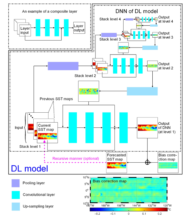
Fig. 1 Architecture of the deep-learning sea surface temperature forecast model to study the Pacific tropical instability waves.
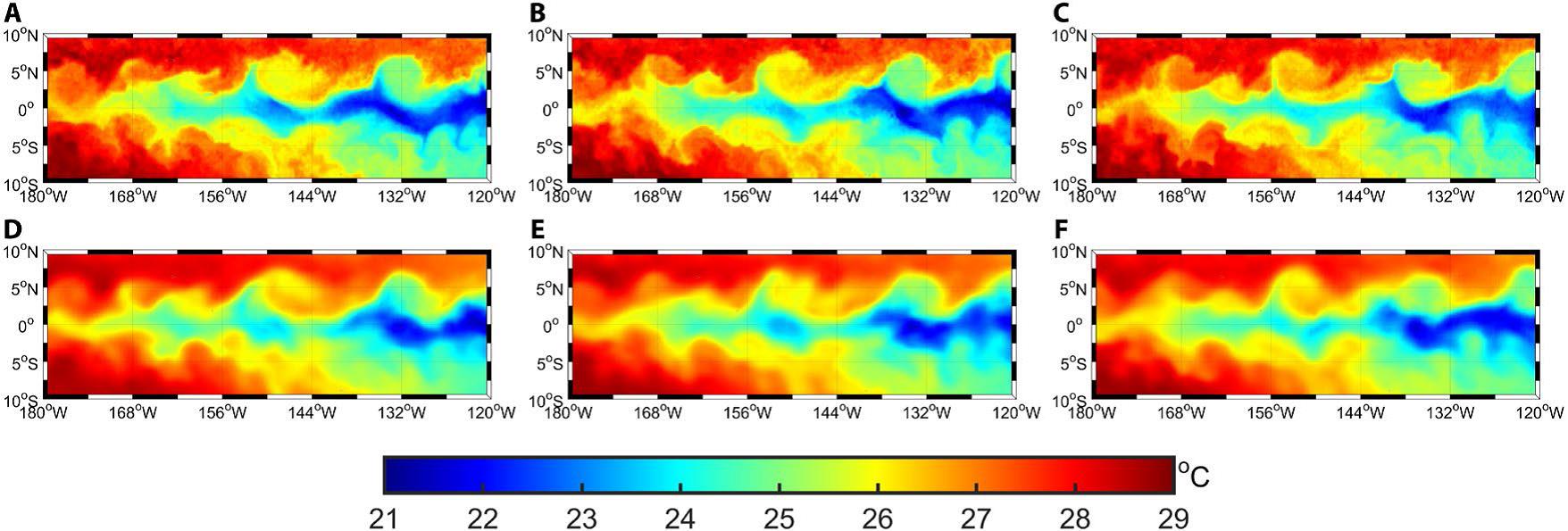
Fig. 2 Satellite-derived (A to C) and deep-learning model forecasted sea surface temperature maps (D to F).